In This Episode: A wild story of several civilians who rescued a piece of history — a little-known account from the sidelines in the race to the moon.
059: Rescuing History
How to Subscribe and List of All Episodes
Show Notes
- Help Support Uncommon Sense — yes, $5 helps!
- This is the second of two parts on rescuing human history. The episodes don’t really need to be consumed in order.
- This episode refers to last week’s, Solving Cultural Amnesia, as well as #038, The Giant Leap for Mankind, my July commemoration of the first human moon landing exactly 50 years before.
- Links: NASA’s Planetary Data System, and Keith Cowing’s space sites SpaceRef, NASA Watch, Astrobiology Web, and Space Q.
- The photos mentioned (and more!) are placed within the transcript, below. Click any of them to see larger.
Transcript
Last week’s episode talked about “Cultural Amnesia” — that electronic records are a lot more vulnerable to loss than paper records, meaning humanity could literally risk losing its history. That even happens in government circles: this week, let’s explore a very specific example from the U.S. space program, and how just a few people with Uncommon Sense stepped up to prevent the loss of irreproducible data.
Welcome to Uncommon Sense. I’m Randy Cassingham.
Last summer was the 50th anniversary of Neil Armstrong and Buzz Aldrin’s landing on the moon, winning the “space race” against Russia, as their crewmate Mike Collins circled overhead in the command module. Before launch, Collins said that he’d probably be the only American that wouldn’t be able to watch that history being made since there was no TV in the command module. He asked news reporters to “save the tapes” for him! Well, this episode shows just how prophetic the idea of “saving the tapes” really is.
In Episode 38, part of the theme was that NASA succeeded with the Apollo mission goals in part because it was given enough money to hire enough people with Uncommon Sense to get the job done. And of course, they were in a mighty hurry to do it not just because of President John Kennedy’s challenge to do it “before the decade was out,” but because we didn’t know whether Russia retained its demonstrated lead in, literally, rocket science.
And here’s an example of what that haste led to.
While the manned spacecraft for Apollo were being designed and built, not to mention the gigantic Saturn V rocket, which would be big enough to get everything to lunar orbit, we launched a number of small unmanned missions to the moon to gather data to support the human landings later.
One of my favorites was the Surveyor missions: we sent seven robotic spacecraft between June 1966 and January 1968 to land softly on the moon to test all sorts of systems, especially soft landing, and to see if the moon’s surface could hold something heavy. Because if a spacecraft simply sank in the fine dust that they expected covered the moon’s surface, we might not be able to get the men who landed back.
Five of the seven Surveyor missions were successful. And one of the most amazing parts of the Apollo missions to me was when Apollo 12, the second crew to land on the moon, had a goal to do a precision landing: they specifically wanted to land near where Surveyor 3 still sat on the moon’s surface.
What blew me away was that they landed so close to Surveyor 3, succeeding in that goal, that the astronauts were able to stroll over to it to inspect the lander, and even remove and bring back its camera and the scoop from the end of its robotic arm. The scoop is on display in the lobby of the administration building at the Jet Propulsion Laboratory, which was, and still is, the primary NASA center responsible for unmanned space missions — and where I worked when I started This is True.
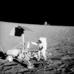
When I had visitors at JPL, the lobby of the administration building was one of the primary places I took them to see something mind-blowing, because not only could they see that scoop, but astronaut Alan Bean took a photo of astronaut Pete Conrad standing next to Surveyor 3, right between the scoop arm and the camera, with their own lunar lander clearly visible in the background. It’s long been my favorite Apollo surface photo, and I’ll include it on the Show Page.
But it’s actually another support program that I really want to talk about. That would be the Lunar Orbiter program, a series of five spacecraft designed to go into orbit around the moon in 1966 and 1967 with the mission to map the lunar surface so that landing sites could be selected for the manned missions to come, and so they could see hazards that the manned landers needed to avoid. All five spacecraft were successful, and managed to map 99 percent of the moon’s surface — yes, even the far side that we can’t see from Earth — in what was, for the time, very high resolution: 60 meters. That means that when looking at the full resolution photo, you should be able to see something that was 60 meters or more long.
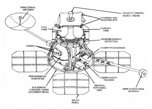
And that high resolution was enabled by something mind-boggling: film! Those spacecraft didn’t have digital cameras, which weren’t even ready to be manufactured at the time. No, they took photographs of the surface with 70mm film cameras, and the spacecraft had on-board chemical processing systems, which worked in microgravity, to develop that film, and then scan the negatives, and then transmit the still-analog photos back to Earth.
“These guys were operating right at the edge,” says an old NASA buddy of mine, Keith Cowing. He was a NASA astrobiologist while I was at JPL, and we both worked on the space station program. He was the Manager of Pressurized Payload Accommodations at the Space Station Freedom Program Office, and one of my jobs was to write a weekly summary of the progress of the Space Station Program, which circulated not just NASA-wide, but also to the White House.
Yeah, it took a lot of Uncommon Sense to use 1960s technology to get the results they wanted to support the Apollo mission, but that’s still not quite the point of this episode.
In the last episode, I talked about the 9-track tapes that were the recording medium for the primary mass computer data storage system of the time. They held a maximum of 170 megabytes of data per reel of tape, so it took quite a few reels to record all of those photos streaming back from the Lunar Orbiter program spacecraft: around 1,500 tapes for about 2,000 photos.
And while those engineers certainly had a lot of Uncommon Sense, they had a much bigger mission they were trying to accomplish under extremely tight deadline pressure. So they got the photos they really needed for the task at hand, then packed the tapes away in storage. And forgot about them. For decades.
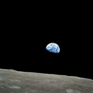
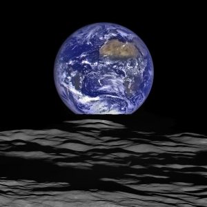
The public was aware of the Lunar Orbiter program because NASA released some of the photos taken by the spacecraft. That included the first photographs ever of the Earth from space. The first was a photo of the Earth rising above the moon, taken by Lunar Orbiter 1 in August 1966: the first “Earthrise” ever photographed, which was a sensation even in low resolution, since that’s pretty much the resolution of newspapers in those days anyway. And the second was the first photo ever of the full disk of the Earth, taken by Lunar Orbiter 5 on November 10th, 1967.
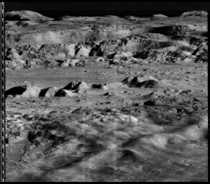
The film scanners of the day scanned narrow strips of each negative into what they called framelets, and it was those framelets that were sent back to Earth. Then, using the best computers of the day, those framelets were output in low resolution, and dozens of them then had to be stitched together to see the whole picture. If they thought they needed to see that photo in high resolution, they’d run the data again in high resolution, which took much longer — and then they still had to stitch the framelets together to see the whole picture. It was a time-consuming process.
But here’s the thing: as I said, they had a big overall goal to accomplish on a tight schedule, so they only processed the photos they really needed, and only used the computer time to get the resolution they needed, before they put the tapes in storage. They never had the time, or even the technology, to fully process the 2,000ish photos taken by the spacecraft into high resolution — and they never made any backups of those tapes.
So then the question was, where were they? Well, luckily they weren’t sitting on a dusty shelf, or they probably would have been completely decayed by now. They had originally been stored in Maryland, but in 1986, coincidentally the year I started working at JPL, the Maryland storage vault didn’t want to keep them anymore, so they were sent back to Pasadena and dropped on JPL archivist Nancy Evans. The question for her was, should they continue to be stored in proper environmental conditions to preserve them, which would soak up a noticeable chunk of her department’s budget? Or should she do what they normally did with old tapes: throw them away?
Evans decided they needed to be preserved. “I could not morally get rid of this stuff,” she said later. She sent the tapes to environmentally controlled storage in Moorpark, California. And there they sat, again, for years, until 2005, when Keith Cowing and his buddy Dennis Wingo tracked them down. And they found Nancy Evans, who by then had retired from JPL, really had Uncommon Sense: she didn’t just save the tapes, she grabbed four of the Ampex FR-900 tape drives when they were decommissioned and theoretically tossed in the trash. They hadn’t been manufactured in decades. They were in a shed, in her backyard, in Sun Valley, near JPL. Keith and Dennis picked them up, got the tapes from storage in Moorpark, and embarked on a mission to set everything up and get the data from the tapes, and process all of the photos they could into their full high-resolution quality, which would be a lot easier in the 21st century than it was in the mid-1960s.
So, did those tape drives actually work? Of course not! They were finicky high-precision devices in the first place, and then stored for decades in a backyard shed!
Still, “These tapes were sealed for history by somebody who cared,” Keith said, “and it was astonishing the condition they were in.” Good condition, he means, unlike those Ampex tape drives. “So we started buying used parts on eBay, [at] Radio Shack,” he remembers. “I was sitting at a black tie reception at one point buying something on my iPhone. We just buy and reassemble these things bit by bit.”
Until they got one working. The thing is, NASA wasn’t interested in helping them. What’s the point in revisiting all that old data when there’s new data streaming down from newer spacecraft every day? “We’re both Apollo babies,” Keith said about himself and Dennis, “so the moon to us was something that’s unfinished business.”
Plus, as an astrobiologist, Cowing knew that having that historical data would be a researcher’s goldmine: they could use them to answer questions like, “Was that crater there before?” So Keith and Dennis funded the project out of their own pockets.
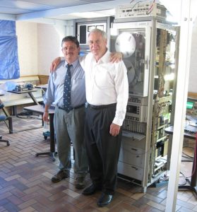
It was a huge project for such a small group of volunteers: Nancy Evans had found old manuals for the tape drives. They found a retired technician that used to work on them to help. They researched the software used to record the data: they had to know the format of the digital records on the tapes if they were going to be able to decode them. There were a lot of obstacles, but they just got started and solved them, one by one. One of the crazy obstacles they faced: the specs for the tape drives showed that the lubricant they used back then was …whale oil!
Then the question was, where to set up to do the work? Cowing still had friends at NASA’s Ames Research Center in California’s Silicon Valley — which happens to be the lead NASA center for Astrobiology. There wasn’t exactly a lot of unused office space available. “I had a choice between the barbershop and this building,” Cowing said, with “this building” being an abandoned McDonald’s restaurant on the Ames campus. “We didn’t really care what sort of building they gave us, we just didn’t want to pay for it,” he said. They were still operating out of pocket.
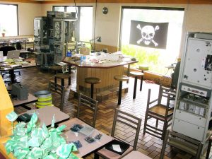
So they set up shop in the old McDonald’s — which they renamed, to McMoon’s — and got to work in 2008. They felt like pirates working on their unofficial project, so they adopted the classic Jolly Roger pirate flag as their icon. There’s a photo on the Show Page of their tape drives standing among the restaurant tables and chairs …and the Jolly Roger hanging in the window. Cowing and Wingo called the project the Lunar Orbiter Image Recovery Project, or LOIRP. They pronounced it “LORP”.
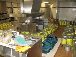
In the 60s, the engineers processing the data would literally print out the framelets, the little strips of each image, and literally paste the paper strips together to see the image. Sometimes they borrowed space in large churches to have enough room to put them up on a wall. Then someone would take a photo of that, with a 35mm film camera, and those resulting, lousy-quality photos were what the public saw. And they still loved them.
At McMoon’s, things were a little more modern: once they had the data digitized, they stitched the framelets together using Photoshop. The first photo they worked on: that Earthrise taken from lunar orbit in 1966. Keith had seen that picture then, when he was 11 years old, and remembered it was “the most beautiful thing I’d ever seen.” He says that blurry photograph was the spark that led him to astrobiology — and to work for NASA.
When Wingo finally got everything running, he called Cowing over and showed him the Earthrise photo. “When that picture came up,” Cowing said, “I had tears in my eyes.” Just like NASA had done 42 years earlier, they released it to the media.
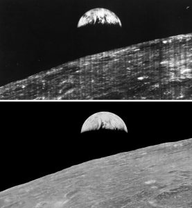
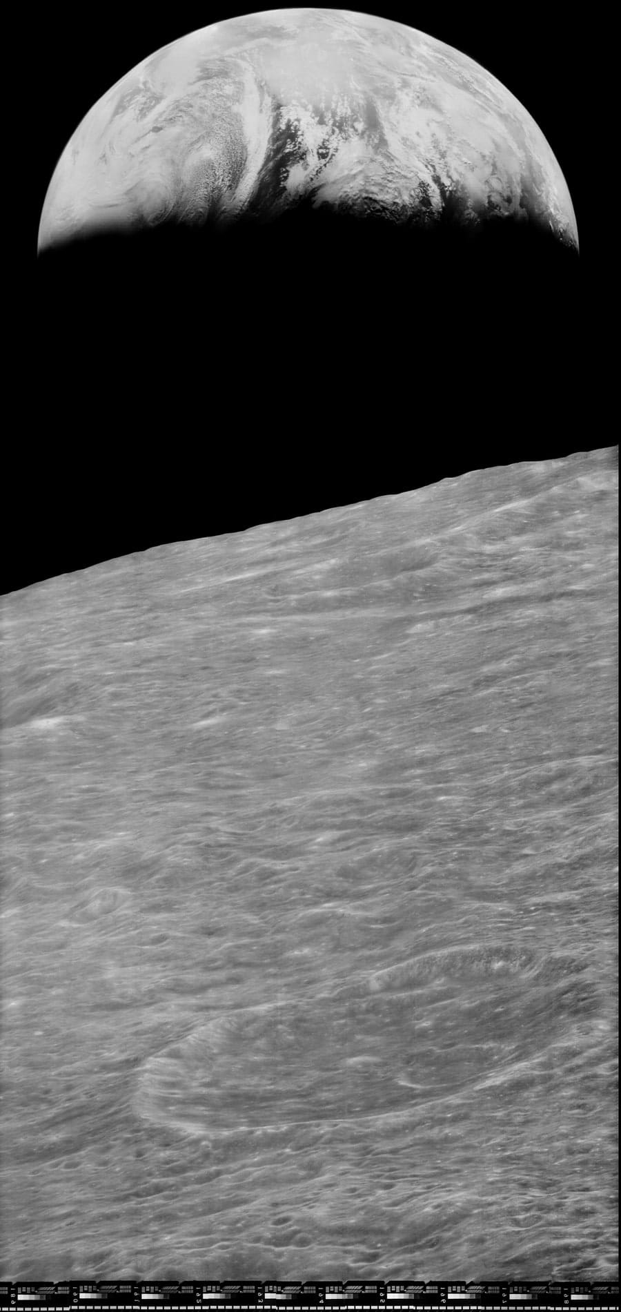
And just like in the 1960s, people were wowed by the now high-resolution photo. “No human eye had ever seen this,” Keith said. “We’re seeing something one order of magnitude more precise right on the screen.” The photograph, processed with modern equipment from half-century-old data, was spectacular, especially when compared to what was released in 1966; I have the 1966 version with the 2008 version on the Show Page so you can see for yourself. It’s so spectacular that the flurry of publicity they got from around the world convinced NASA that they needed to fund LOIRP to keep it going, since after all, that attention-getting photo produced in its full glory “proved the concept” of the project. The proof Cowing and Wingo themselves didn’t need to get started, because, well, they had the Uncommon Sense to have the vision in the first place.
They found the tapes weren’t labeled consistently. “It’s like a library undergoing the switch from Dewey Decimal System to Library of Congress,” Keith said early in the project, “and then you have an earthquake. That’s essentially what happened 40 years ago.”
“It’s like figuring out a dead language,” Wingo agreed. “It took us forever to figure out, for example, that the Sequence Numbers on the tape cans actually represent orbit numbers.”
In June 2009, while they were working to recover all those photos, a new orbiter arrived at the moon. The Lunar Reconnaissance Orbiter, or LRO, had the latest digital cameras available, with 100-meter resolution. But if you remember, the film-based system on the original 1960s Lunar Orbiters had 60-meter resolution! “Our imagery from 1966 and ’67 has sometimes greater resolution and greater dynamic range,” Keith said, “because of the way the pictures were taken. So sometimes you look into a shadow in a picture that LRO’s taken, and you don’t see any detail. With ours, you do.” They were able to recover nearly all of the recorded images from the 1960s.
Plus, with LOIRP and LRO, researchers now have two sets of data so they can see the changes in the moon between the 1960s and today. Even better, with the images taken of 1960s Earth, researchers have been able to refine data of terrestrial conditions in those days, such as arctic ice levels.
In all, NASA only contributed $250,000 to the years-long project; volunteers put in another $100,000. When Nancy Evans had tried to get NASA to fund the same idea earlier, officials estimated that it would cost $6 million, and said no. Happily, she was flown up to Ames to be there when the new Earthrise image was released.
Once the project was completed, with the photos being made freely available online, all the full-resolution LOIRP data were imported into NASA’s Planetary Data System, which was designed to stop the problem of lost data from more modern spacecraft, like photos from JPL’s probes to Venus, Mars, Saturn, and Jupiter, and their moons. And who started that data repository? It was co-founded in 1989 by …Nancy Evans, who, Keith told me over the weekend, died 10 days ago, on January 17.
Keith, now 64, left NASA to be …an online publisher! He’s the president of SpaceRef Interactive, which naturally concentrates on space-related initiatives, and as a watchdog over NASA. The sites include SpaceRef dot com, NASA Watch, Astrobiology Web, and Space Q, which covers Canadian space agency efforts. As for McMoon’s, Keith told me its fate, too: “Now that the project is over it is back to its original purpose as a coffee shop for NASA Ames employees,” he said. “Had we not used it for the project, it probably would have been torn down.”
NASA has a harder time buying Uncommon Sense these days: its budget peaked in the mid-60s at not quite 4-1/2 percent of the federal budget. Today it’s less than 1/2 percent of the budget. Yet people with Uncommon Sense like Dennis Wingo, Keith Cowing, and Nancy Evans can still make an amazing difference.
And happily, someone is here to tell their stories!
The Show Page for this episode is thisistrue.com/podcast59, which includes photos, links, a place to comment, and a way for you to contribute to support this podcast so that it can continue to bring you these stories with no interruptions by ads. Even $5 really helps. The second best thing you can do is to recommend your favorite episodes to a friend. Thanks!
I’m Randy Cassingham … and I’ll talk at you later.
– – –
Bad link? Broken image? Other problem on this page? Use the Help button lower right, and thanks.
This page is an example of my style of “Thought-Provoking Entertainment”. This is True is an email newsletter that uses “weird news” as a vehicle to explore the human condition in an entertaining way. If that sounds good, click here to open a subscribe form.
To really support This is True, you’re invited to sign up for a subscription to the much-expanded “Premium” edition:
Q: Why would I want to pay more than the minimum rate?
A: To support the publication to help it thrive and stay online: this kind of support means less future need for price increases (and smaller increases when they do happen), which enables more people to upgrade. This option was requested by existing Premium subscribers.

Thanks so much for your detailed commentary, Randy! I read the transcript, and have passed this on to my archivist friends. Nancy and Friends deserve a Nobel Prize for Historical Preservation!
She deserves an Honorary Unsubscribe. Awesome lady.
—
Indeed so. Sadly, pretty much the only public info I can find on her is in relation to the project. -rc
I was amazed to see this story again. I read about it sometime back but not all the detail. Thank you.
Anyone looking for the full image set can find the official NASA posting here:
https://pds-imaging.jpl.nasa.gov/data/lo/LO_1001/EXTRAS/BROWSE/
It’s not particularly user friendly though, this mirror has an easier to use UI; and from the brief spot-checking I’ve done appears to have done a better job of adjusting the contrast in the .jpg images.
https://www.lpi.usra.edu/resources/lunarorbiter/
—
Thanks; I was already running late enough and didn’t go looking. Those at least appear to be different data sets (as in different processing or interpretations), and appear to be less manipulated data — not quite as perfected in the pasting-together of the framelets or adjusted for contrast. Easy comparison: the Earthrise photo, which is Orbiter 1’s Frame 1107; the “H2” crop seems to be the close-up of interest. On the former site, here, and on the latter site, here. And neither seem to be “full” resolution, and I’m unclear if civilians can get that at either site and if so, how. -rc
This paragraph:
reminded me of my Dad. He was one of the computer engineers responsible for trying to capture all the data streaming down onto the tape drives. I distinctly remember him telling me that one of his tasks while working for IBM at NASA was to “bypass the operating system” and “write as much data to as many tape drives as possible” in order to keep up with the data stream.
—
Interesting! -rc
I thoroughly enjoyed this episode and going to the NASA site to find the “high” resolution image was mind-blowing.
I was surprised to see the data was recorded on the 9 track machines. We were maintaining the Ampex FR-1400 machines at the Patrick Tech Lab at the time and they were in pretty wide use.
—
The 9-track drives were very common in that era. -rc
A magnificent story! Thank you *VERY* much for telling it. Absolutely incredible that they accomplished all that on a volunteer/out-of-pocket basis. (smh) Kudos to Dennis & Keith for their dedication to this project, and MASSIVE MEGA KUDOS to Nancy Evans for having the foresight & uncommon sense to save all the tapes, tape drives, & *the tape drive manuals*!!!
—
Yeah, grabbing the manuals was a nice touch! -rc