
I live in one of the most beautiful parts of one of the most beautiful states in the union. If you’ve been following this blog, you know I work a lot, and know I stare out at the mountains from my office window — I have a great view.
Recently I decided it was time to spend more time outside, living in the view, rather than just looking at it. This is the story of taking just one day off this week.
I never do anything in a terribly conventional way: I took off from 5:00 p.m. Wednesday to 5:00 p.m. Thursday….
Note: Clicking on any photo will give you a bigger size to see it better.
Note 2: There has been no color “correction” on any photos. Differences in sky tone are due to normal camera exposure compensation. You’ll quickly understand why they call this state “Colorful Colorado”. Really: the mountains look like that when you’re close up!
Orientation
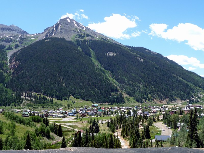
My house is on a mesa looking at two portions of the San Juan mountain range: the Sneffels section, which features the 14,150 ft (4,312 m) Mt. Sneffels, and the Cimarron range.
The point of the valley where the two meet is the town of Ouray (aka “Switzerland of America”), our county seat, and an old mining town. It’s an extremely charming town, but not for me to live in: I like to be back a bit so I can see the mountains, and being in such a tight canyon, it doesn’t get much sun. And being in such a tight canyon, there isn’t much unbuilt land. By going north a bit, I not only got the views, but I was able to afford the 45 acres (18.2 Hectares) I live on.
One of the very cool things about Ouray County is it actively encourages people to explore the back roads in the mountains — and we have a lot of mountains. The county is 542 square miles (1,404 km2). The county spends a lot of its limited resources to maintain the jeep roads, but volunteers help too. The Western Slope 4-Wheelers jeep club, for instance, has helped improve roads by going so far as to help build bridges and clear avalanche debris.
Choose Your Vehicle
Naturally, my first thought was to get a jeep. I went out with a friend in the WS4W club a few times, and I liked it, but it’s a fairly slow and expensive hobby. After thinking about it for a long while, I decided that wasn’t the direction I wanted to go, even though I really liked the idea of exploring those back roads and old falling-down mining towns.
Then a good friend got a new toy. Dave Casler and I have a lot in common. He’s a fellow writer, a fellow publisher, a fellow photographer, a fellow techie, and a fellow ham radio operator (that’s how I met him: when I first arrived in Boulder, he was the first local I made contact with on the radio — literally, from my car as I first rolled into town). He writes novels, and his small firm, Mt. Sneffels Press, publishes them in addition to other books.
His new toy: a street-legal dirt bike. “Dirt bike” gets you around on the steep jeep roads. The “street legal” part gets you to the start of those roads without having to fool with a trailer, or worry about whether you need a licensed vehicle while on public lands.
Dave and I have so much in common: when he got a new toy, I wanted one too! So I got one; for those who know bikes, it’s a Suzuki dual-sport; a DR-Z400S:
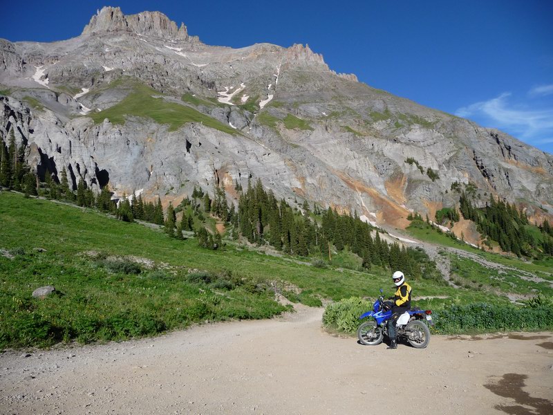
It was a fantastic day to go riding: the weather was gorgeous, as you can see. Something else you might notice from that shot: it’s pretty steep up there. Ouray is pretty high in elevation: about 7,800 ft (2,375m). Where this shot was taken in Yankee Boy Basin (named for the Yankee Boy mine, or maybe vice-versa), the elevation is about 11,400 ft (3,475m) — and it’s only about a 7-mile ride. (And a lot of it is fairly level!)
Warm-Up
Since I started the trip at 5:00 p.m., and the sun went down around 8:30, that’s all we did that day. It was a warm-up for the next morning.
Dave and I both have street bike experience (him a lot, me a little), but not much dirt experience, so we like to go out with other, more experienced riders who know the back roads well, and can give us some tips about the hard parts: novices can get into real trouble really easily.
The road to Yankee Boy Basin, for instance, has several places where there is a several-hundred-foot drop right at the edge of the road. Guard rails? Forget it! We can’t afford guard rails on our highways around here! (Seriously.) A nice wide shoulder? Sometimes the road is cut into the cliff with dynamite, and they’re not going to make it any wider than absolutely necessary.
Or any taller, for that matter: in one spot the road is literally a C-shaped gash in the cliff: there’s rock directly over your head. So all you get is one jeep width (or really: one mule train width!), which is plenty for a motorcycle.
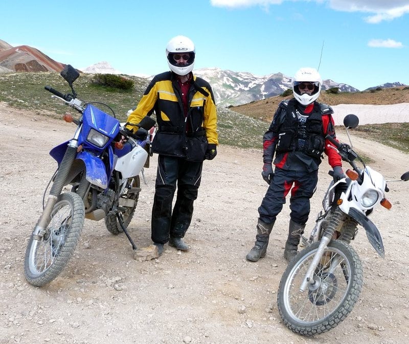
So for the next morning, the long ride, we arranged for a tour from Terry. He’s a friend-of-a-friend who has been riding the back roads for decades, and he was itching to get out so much that he was willing to take on a couple of novices. We met at Ironton, an old mining area well above Ouray, to do Corkscrew:

Start at nearly 10,000′
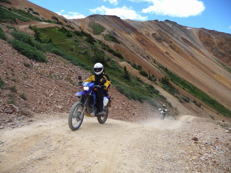
Ironton, right alongside U.S. Highway 550, is on the far side of the gorgeous (if a bit white-knuckle) Million Dollar Highway portion of the highway. It’s at 9,800′ (3,000m), and after a quick briefing from Terry we all headed up a steep dirt road — one of Ouray’s county roads. Dave turned on his GPS tracker as we got going.
As we started up the side of Red Mountain 1, you can see the switchbacks in the road — as the contour lines on the topographic map show, it’s steep:
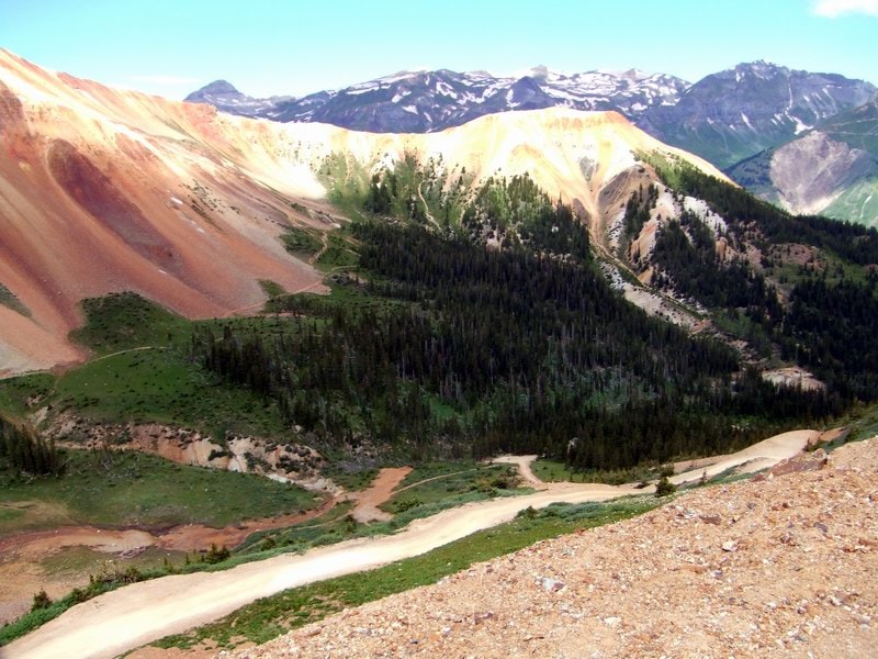
I stopped at that switchback to rest, and turned around a bit from the angle of the previous shot to get a photo of the basin we came up through:
From there, it was a relatively easy ride down into Silverton, another old mining town in another tight valley that’s another fun tourist attraction:
We stopped in town and bought Terry lunch, and were riding out on another dirt road just in time to see the train come in from Durango — the Durango and Silverton Narrow Gauge Railroad, which I need to ride someday:

We got back on Highway 550 toward Ouray, but at the county line popped back up into the hills again to see some more of the old mining areas:

Hardy People
Hard rock mining is a tough life, but there are hundreds of mines in the mountains around here. This is the top of a mine shaft: a shaft is vertical (think elevator shaft); a horizontal mine bore is called a drift. The falling-down structure at the top is the headframe, the top of the shaft.
Miners — and mules! — were lowered down into the mine from here to do the digging and bring the ore back to the shaft, and the ore was brought to the surface with power from a hoist house (not shown above: it has collapsed).
The weird looking brown stuff? Those are tailings. Most of the time, there’s a mill that separates the desired mineral from the ore (usually metals in these mines, especially silver), and the tailings are what’s left — the largest fraction of the ore, and it’s just tossed aside and left in huge piles.
Unfortunately it’s often pretty toxic, with acids, arsenic (especially in gold mines), mercury and other nasty stuff — note that there are no plants growing in the pure tailings, even though this mine was probably abandoned in the early 1900s.
I love these old falling-down structures; I think they’re gorgeous. There’s even a horrific beauty in tailings; check this pile out, taken from across a small valley:
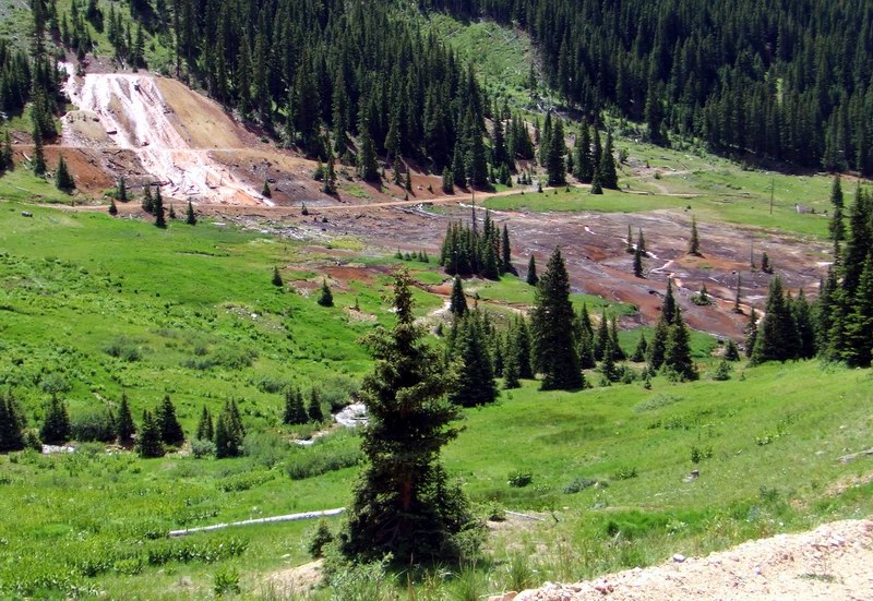
I don’t know if the waterfall was there first, or the tailings (my guess: the waterfall), and the water is carrying toxic gunk across the meadow, killing just about everything in its path. (Yes, there’s plenty of clean-up work in progress in these mountains.) I find this grotesquely gorgeous, even though I can see the environmental damage done by this.
And yes, it bothers me that in most cases with these mines, “someone” came in, pulled out their fortunes, and then moved on, leaving some other generation to clean up the mess later.

Our last stop was the fairly famous Yankee Girl mine site, which was saved from destruction just recently:
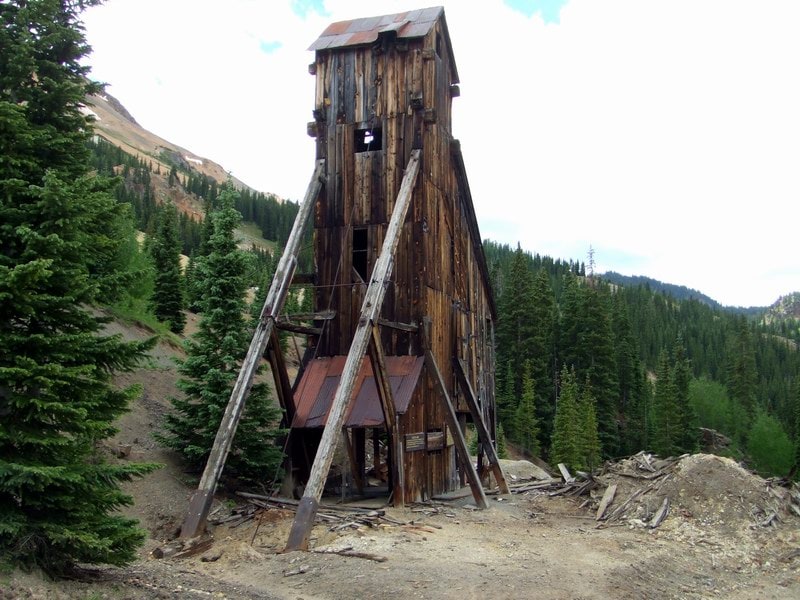
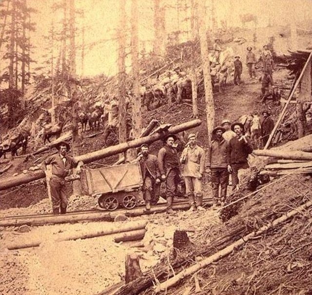
The Yankee Girl (established 1882) was a rich mine, producing huge amounts of silver and gold from its vertical shaft, which goes down about 1,000 feet. It was so rich with silver that the ore fetched up to $10,000 per ton — in the late 1800s — without even going through a mill first. Here’s a photo from the era — 1888:
All told, in the two trips we rode more than 150 miles, mostly on dirt roads that would probably terrify the average flatlander. Yep: I’m getting my heart pumping a bit more, not just sitting at a desk!
Many thanks to Matt Goetsch of the Western Slope 4-Wheelers jeep club for help in identifying the mines shown in some of the photos on this page.
—
Update: Once I saw what I wanted of the backcountry, I sold the bike in favor of a different hobby.
– – –
Bad link? Broken image? Other problem on this page? Let Me Know, and thanks.
This page is an example of Randy Cassingham’s style of “Thought-Provoking Entertainment”. His This is True is an email newsletter that uses “weird news” as a vehicle to explore the human condition in an entertaining way. If that sounds good, click here to open a subscribe form.
To really support This is True, you’re invited to sign up for a subscription to the much-expanded Premium edition.
Sounds like an awesome trip, it makes me want to come over there someday just to have a look at the countryside. Good to hear that you are also now giving yourself some time to get out of the office.
This is a fantastic article. I’ve Jeeped about half of what you describe above, and it is slow. I also have a DR-350 Suzuki, daddy to your 400, with over 50,000 miles on it. And I’ve accidentally taken a big street bike down Schofield Pass.
Again, great piece above. I enjoyed reading it.
You living in a place like that and bragging about it makes us hate you :p hehe.
I was in that area a couple of years ago on a motorcycle, truly one of the most beautiful places in the world by any standard. ‘grats on the DRZ — nice ride.
Thanks for sharing, Randy. I was in Colorado some years back and my hosts took us to an old mining town, where the mine was boarded up and was now the fire station. It was a wonderful trip.
The photo of Corkscrew Gulch looks almost surreal because the colors seem so odd. Is it because you didn’t have a filter on the camera, or is it really that way?
I also enjoyed the picture of the 1888 miners. Can you imagine having to work in mines in those days? What brave men they must have been.
—
The colors are odd there, but indeed my camera is unfiltered and the light was harsh — but a cloud was shading the trees in the middle right, making the whole scene seem even more odd. And the three Red Mountain peaks are called that because they really are red, which makes it all the more weird to look at. -rc
FYI, street legal dirt bikes are great fun, but watch out: the knobby tires can be very squirrely on the pavement. Be very cautious when riding on paved roads, especially around corners. I know from experience 😉
—
I indeed am cautious — so much so that I was actually quite surprised how well it grips on pavement; I was expecting much worse. -rc
Wow! You fellas out west are blessed with very beautiful and rugged places to motor around in! This was really enjoyable to get a peek into your leisure times.
Of course I also just had to click on the link to see what the Western Slope 4×4 club is up to. The photos of ‘rock crawling’ and the stresses they put their Jeeps through were just amazing to me. As a former east coast 4×4 enthusiast (International Harvester 1969 Scout), I actually felt sorry for some of those Wranglers pinned against rocks or twisted into all manner of odd positions. Here on the east coast our rides were entirely different (the snow of Vermont, the sand of Cape Hatteras in North Carolina, the mud everywhere in the deep south). We were crazy to take some of our rides, but you guys are nuts! lol
Thanks for this glimpse into your country, Randy. I completely understand the excitement of a thrilling ride into a beautiful setting. It’s one of the best medicines around. Good on ya!
—
Yeah, my buddy Matt, who I turned to for identification of some of those mines, is one who when faced with a clear path or going over a huge rock, he’ll take the rock. He’s got a fantastic vehicle for it, and he let me drive it over Imogene Pass, which was a thrill. -rc
You really DO have to ride the Durango-Silverton train. It has terrific views and is quite a pleasant ride from between the 2 towns. (Not to mention all the views that you’ll recognize from various movies!)
Been there several times and know exactly what you’re talking about. I have a 5 frame panoramic photo of the Red Mountains taken from almost the same spot as your shot on the bike. (My kids pointed out the knife, spoon, and fork on the side of the mountain.) We live in the flatlands, but love the mountains, and it’s pretty convenient to rent a Jeep for a day.
We plan to start on Engineer, to California, and come out Corkscrew at the end of July. But we’ve always thought a dirtbike looks like a fun way to get up and down those beautiful mountains.
Thanks for writing so clearly that we can almost have a virtual ride with you. The photos are awesome, as is the scenery. Breathless…
I saw Colorado for the first time when I was twelve, and could hardly believe that a sky could be THAT blue – or that rock could be THAT red. (I thought it was just the postcards we had seen.)
We’ve been through Colorado many times on trips to places beyond, and it has never disappointed us. This is a sweet reminder of many interesting side-roads that are still waiting for us. Thanks so much.
Yes, Caroline is right- you need to ride the Durango-Silverton line. I went on it when I was 13… 36 years ago. I still remember the amazing ride. It was wonderful fun to view the scenery and to experience riding a train similar to what was used decades ago. The train was a highlight on a trip with many, many memories that I cherish.
Nice ride report Randy. As a long time rider (first powered two-wheel ride was in the late 50s), I enjoyed the read and photos. A double thrill, biking and the history that surrounds us that so many don’t get the opportunity to enjoy. Your machine of choice and route taken made a great report.
Oh, Great. Another stinky, noisy, smoky, smelly, polluting, dangerous, destructive gas powered machine racing around in the mountains. You would be healthier on a bicycle, or better yet, on foot.
—
I was on a road the entire time, so there was no “destruction”. I respect your choice to experience the mountains your way. It sure is sad you disrespect mine, which doesn’t impact you in any way. -rc
Great trip report. You might enjoy some of Stephen M. Voynick’s books, particularly “Leadville: A Miner’s Epic”. He lives in Leadville now and lived the life of a hard rock miner, then wrote of his experiences. I enjoy your blogs… all of them.
‘Bout time you got out and smelled the Columbine! Ain’t Yankee Boy Basin great!?! I find that I enjoy the area’s roads much more in a jeep than a bike – on a bike I have to pay too much attention to the road, even if I go slow. All of your photos are very familiar to us. We will be in Ouray from Aug 6 to the 13th. I may look you up. Then again, we are camping on our claims above the Bachelor Mine and we plan to have between 10 and 12 kids up there with 5 adults (Yes, we adults always seem to be outnumbered), so things may get a bit tight and I may not be able to get away. Ouray’s pool is about the only place I get to relax – what a wonderful asset to the community. I just hope the weather is more mild this year – lots of wind and rain last year, which was not especially fun during our campout. BTW….I recommend Last Dollar Road during the aspen color change – AWESOME!!!!
Regarding “Ray, Hinesburg, VT”
Unless Ray certifies that he NEVER uses a gasoline-powered vehicle for recreation, he’s nothing but a hypocrite that deserves to be slapped down, not just tsked at like you did, Randy. I looked up your bike: that trip of yours used less than 3 gallons of gas.
And talk about missing the point. Your report was not only interesting and entertaining reading, it educated us all about what there is to see in a natural area that most of us will never be able to get to in person. It also taught us to see the beauty of even ecologically destructive historical acts, and (for those who are willing to think about it) lessons about what we have to be willing to pay if we want things like silver and gold jewelry.
Yet Ray can’t see any of that from his lofty perch of fake superiority. All he can do is whine from a position of ignorance and hypocrisy. What an idiot. The only waste of resources here is what it takes to keep him breathing — and using the Internet!
To Ray from VT…The bike Randy was riding was a 4-stroke, not a 2-stroke (if you don’t know the difference, google it). It gets about 40mpg @ the kind of riding he was doing, and it’s very quiet in stock form, which it appears to be in photos. If you are who you pretend to be, I’m certain you ride your bike to work in the wintertime in Vermont. Am I wrong? Randy probably has a much smaller “carbon footprint” than yourself based on the mere fact that he works at home. BTW, exactly what is your position with the “environmental police”? One last thought, to which you will probably take offense, although not intended… “A fool knows the faults of others but does not see his own.”
—
Actually, I got 55.5 mpg on that trip. -rc
The photos were great. I have never been to your area.
I don’t believe I would want to be there in the winter time. It gets cold enough here.
Thank you for a good story & some great pictures.
—
Yeah, it can get cold here in the winter, but rarely is it too cold for me. Luckily, one can often choose when to travel. 🙂 -rc
If you would like to find a great group of like-minded individuals that know your area like the back of their hand, plus can provide assistance if you happen to breakdown in the back country please check out http://www.advrider.com — an adventure riding forum for motorcycles. Scroll down through the forum and you will find a regional group that will have many riders in your area. When you first log on you will see a bunch of pictures taken by members of the forum that are some of the best motorcycle pictures you will ever see. Besides your home area there are ride reports from around the world. ENJOY!!
Thanks for the tour through the mountains.
Back here in Jersey near where I live, we don’t get quite the elevation changes: A lot of our riding is in sand and swamp.
Anyway, as I also ride a DRZ400S, my first suggestion is to get some real tires on that bike. You can get a much more aggressive street legal tire, and they do work fine on the roads as well. And get a trickle-charger, as the DRZ-S has (had?) a nasty habit of draining the battery if not used (like over the winter).
Last, Look to where you want to go. Your ‘lay-down’ was possibly due to you looking at the road in front of the tire instead of the path you need to take. Target Fixation can work to your advantage: Make sure to look where you want to go.
Have fun, stay safe, and try something new every so often: You’ll be surprised what that bike can do.
—
Terry did advise new tires, gearing down a bit (which would have helped with my trouble spot), and rejetting the carb for altitude. I do already have a float charger from my old ATV, now sold. Thanks for the suggestions! -rc
Thanks for the post. A couple of years ago for Christmas my brother and I gave our parents the gift of travel. We asked them to pick a place (anywhere in the world) they would each like to go and my brother and I would cover the expense. My father chose Durango, CO specifically to ride the Durango-Silverton train. We’ll be heading out that way in a couple of weeks to ride the train and see as many of the sites as we can in the short week we will have. Your pictures have made me even more anxious to get the trip underway.
—
What a cool gift for your parents. Glad you’re finally getting going on the trip(s)! -rc
Thanks for the mountain ride blog! A few years back I did the Imogene Pass route on a BMW F650, from Telluride to Ouray. Pretty impressive scenery to say the least. Looking forward to coming back some day!
—
I’ve driven Imogene (a 13,114′ dirt road pass) in a Jeep, but not yet on my bike. It’s on my list, though! -rc
Wonderful photos. My husband and I visited Lake Dillon a few years ago, and had a wonderful time. I would like to go back to Colorado one day for another visit. Ouray looks like a good choice!
—
It definitely is a gorgeous area to visit. Hard to get a job here, though — I had to bring mine with me. -rc
Thanks for the article. As a transplanted Coloradoan, this reminds me of the trip my wife and I had trying to go from Marble to Crested Butte in our VW Beetle. I loved the scenery and the drive but my wife made me turn back around before we got to the top and still has not forgiven me (40 years later) for the attempt. My brothers, sister and I enjoyed growing up in the mountains as our parents taught us to enjoy our country. Dad taught us about the old mines and the damage that is still being done by the old mines.
Thank you again.
Great pictures and story. Thanks for the reminder, I went on a two-week tour in that area in 1970 with the rest of crew from Little Percent Taxi out of Aspen, now defunct).
Here’s a site I recently discovered: http://www.14ers.com
—
There are 54 “14ers” in Colorado — mountains with peaks at 14,000′ or more. That site lists them all, with photos and a forum. -rc
Back in the mid 70’s I visited a friend in Montrose and we took our bikes from 550 over Black Bear Road into Telluride and then Ophir Pass back to 550 – the Million Dollar Highway. I will always remember that ride – you MUST do that one day – you will NEVER forget it!!!
I GOTTA get back to the mountains!!!
—
Yep. And the thing is, just about all the rides around here are that good! -rc
Congrats on the new bike. As someone else has commented, you do need to take the Durango-Silverton RR. That was a highlight on a trip we took a few years ago. Last year we came out and took the Alpine Loop from Lake City to Silverton and back in a rented Jeep. The American Basin was in full bloom… what an awesome, awesome time that was!!
Being in the middle of all that beautiful country, you def. need to get out and explore more. It lets us flat-landers live vicariously thru your blogs!
Welcome to the world of dual-sport riding! I just started myself a few years ago, and have never regretted it (I ride a KLR 650). I envy your location: That is my favorite part of the state, but I rarely have time to get that far south.
One thing that helped me out enormously on the dirt was a riding clinic hosted by “Neduro”, if you can ever get to one. Next best thing are a pair of videos he put together which can be found here: [link removed, no longer online]
Mom & I rode the Durango-Silverton Railroad a few years ago as part of a Collette Vacation featuring 5 Colorado railways. It was a beautiful ride. The area has been used by Hollywood for movie sets. We also enjoyed the Royal Gorge train and the Toltec. Colorado’s landscape is varied – I didn’t realize how different until I rode those trains. I can’t wait to get back to your state!
I was just telling my daughter that this was what I most missed from Colorado — being able to jump in the car, pick a direction, and find an adventure, all within less than a day’s ride from home. We’re still getting to know Washington state, but they’re not as explorer-friendly as Colorado, or maybe I’m just not putting the energy into it I used to 🙂 Thanks for the pics, Randy. Brings back lots of memories.
Can you post a photo of a tight switchback or a “C-shaped gash in the cliff”? I like living vicariously through other people’s much-too-scary-for-me excitement.
Great post. Thanks!
—
I don’t have any photos currently, but I’ll endeavor to get those. -rc
Congrats on the new toy. The DRZ400 is a great ride in any trim. A buddy of mine rides a DRZ400SM. If I lived in and around terrain like that I would be riding the same and I wouldn’t have time to work. 🙂 You are a lucky man.
Derrick, Caroline is absolutely correct – be sure to have fresh batteries or your camera fully charged and an empty memory card. I rode the D/S in winter so it only goes half-way, but still a magnificent ride. Enjoy your trip!
Glad you had a good time, and that such wonderful places to ride are nearby your house. (Here in suburban Central Maryland, we don’t have those kinds of rides out the backdoor, but we can go to Pennsylvania, Western Maryland and northwestern Virginia easily enough. It’s still not the wide-open you have though!)
Since you and your friends will be undoubtedly doing more riding, the worry-wort in me just wants to remind you to:
1. Always tell someone where you are going and when you expect to be back. If something goes wrong, someone will know when and where to look for you.
2. Always carry what-if emergency supplies with you, good maps, firemaking, signaling, shelter-making, first-aid and so on.
3. Consider carrying a PLB, a Personal Locator Beacon, with you. In an emergency, at the push of a button, a PLB will call for help by satellite from almost anywhere with a high-probability of reaching aid. The best way to survive is to get out of danger as quickly as possible.
Getting of my worry-wart soapbox now. Thanks for the weekly fun — I’ve been a subscriber since early when it was This Just In!
—
That’s quite a while, then. I do carry quite a few supplies, including a GPS and my county two-way radio. I would be able to actually talk to any responding ambulances, mountain rescue crews, troopers, or deputies. -rc
I’m glad to learn that your bike is so non-polluting (4-cycle, et cetera). Please allow me to say to Rick, Washington on July 12, 2009, that everyone can be/should be “environmental police.”
I have never been to CO. I have flown over it on my way to Las Vegas, NV. I was able to see Pikes peak from 28000 feet up.
You story was a very good read.
Thanks for this story & the Great Pictures.
Ray in Vt whined about “Another stinky, noisy, smoky, smelly, polluting, dangerous, destructive gas powered machine racing around in the mountains.”
Yeah, Randy: your quiet, fuel-efficient, smog-controlled means of conveyance is absolutely defiling the toxic wastes leaching out of those mines. How dare you, sir?! How DARE you!
On another front, you’re right that it’s both ugly and instructive to see examples of people not applying thought before reacting. No doubt, Ray misses the entire point of that.