
In This Episode: A story in This is True struck me as an astonishing example of Uncommon Sense, so I thought I’d tell you about it to see some really out-of-the-box thinking, and provide some practical advice that could save your life. Here’s a hint: no one thinks they’re going to get lost and need rescue. Yet there are tens of thousands of rescues every year in the U.S. alone. What will increase your odds of being safe? Uncommon Sense.
090: Rescuing Uncommon Sense
How to Subscribe and List of All Episodes
Show Notes
- Help Support Uncommon Sense — yes, $5 helps!
- See below for the True version of the story, and the several photos. My new site is what-its-like-to.com, and Submission Guidelines are here. You can also read the stories on Medium if you prefer.
- Products I use/mention*: Pocket flashlight, about $30. The portable battery pack I have is discontinued, but if I was going to buy again I’d start with Anker, about $35. The GPS app I use on Android: GPS Status & Toolbox, which is available in free and paid (no ads) versions (I paid: $2.49).
Mike’s Story about the Rescue:
Picture Perfect
Rene Compean, 45, texted to his friend: “SOS. My phone is going to die. I’m lost.” He also sent two photos to relay his location, but only one got through, showing his legs and some of the surrounding terrain in California’s Angeles National Forest, where he’d been hiking. The photo had little information, especially since the poor signal meant his friend received a low-resolution version. Worse, the phone’s location settings were disabled, so the photo didn’t include those details. The Los Angeles County Sheriff’s Department sent a Twitter call for help along with the photo: “Are You an Avid Hiker in the Mt. Waterman Area? #LASD SAR Teams need help locating a #missing hiker.” Ben Kuo, 47, saw the photo and thought, “I bet I could find that spot.” He has an unusual hobby: “I have always loved looking for where photos are taken.” He’s able to identify locations from photographs or movie scenes by cross-referencing them to satellite imagery. He quickly located and tweeted a screenshot of his findings on Twitter, then called the sheriff’s department. Compean was rescued. “I’m so lucky that Ben did what he did,” Compean said. “I’m thankful to be alive.” (MS/Washington Post) …Privacy settings: sharing what you want to keep private and keeping private what you want to share.
Transcript
Welcome to Uncommon Sense; I’m Randy Cassingham.
Before I begin, yes: it’s been more than two months since I’ve released an episode, and without prior notice. Sorry: I’ve been working on a new project and I couldn’t do both at the same time. That would be a new web site and publication called, “What It’s Like to…” — What It’s Like to Save a Life, or make a Death Notification to the “next of kin.” What It’s Like to Survive Cancer, maybe thanks in part to the guy who wrote What It’s Like to Donate Platelets.
I’ve always wanted to know the answers to questions like that, so I built out the web site using a magazine design style that I’ve never done before, decided on how the stories would be laid out, which implies a style and a word count (which in this case is 500-600 words to arrive at a 3-minute read for each story), and how readers could submit their own stories — because I haven’t done everything and I wouldn’t want to write them all anyway. But I did have to write several to seed the site and provide examples, and I do have some stories I want to tell.
Happily, my wife has done some interesting things herself, and knows how to write, so I got a couple from her, too, to demonstrate different voices. Anyway, that took up quite a bit of time. The site launched at the beginning of March, so the podcast is, for now, on a “when I have time” basis. Still, I thought it was time for an episode so I kicked up the priority a bit, especially since I have a cool story to tell.
The new site is at what-its-like-to.com (with hyphens between the words), and of course I’ll link to it on the Show Page. Also, if this quick description has sparked an idea that you might want to write, see the web site for submission guidelines. (I’ll link to that page too.)
So with that, on to this episode’s story, based on a This is True story by contributor Mike Straw, which I’ll include on the Show Page.
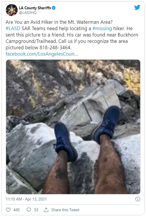
The Los Angeles County Sheriff’s Office sent out an urgent tweet with a blurry photo. The photo was taken by a guy who was lost in the Angeles National Forest. On the second day in the woods without adequate clothing, food, or water, he found a cell phone signal and sent out a plea for help.
He also took two photos to show his predicament and location, texting them to his roommate. By then his phone battery was down to 10 percent, so what the roommate actually got was one of the photos, and a blurry, low resolution one at that. You can see it on the Show Page. His roommate replied, asking if he should call the police, but that didn’t get through: his phone battery was too low to work anymore, so Rene Compean, 45, couldn’t send any more clues that might help lead to his rescue.
Luckily, Compean’s photo and message — “SOS. My phone is going to die. I’m lost.” — at least got through, and his roommate did call 911. Unluckily, the one photo didn’t really show where he was, and the location tags for photos had been turned off.
Still, it was something to go on, so the sheriff’s office tweeted out the photo and the general area where Compean was known to be, because they had already been looking for him and had found his car. That was smart, but not exactly Uncommon Sense. For that, enter Ben Kuo, who doesn’t even live in Los Angeles County, but he still spotted the sheriff’s tweet asking for help.
Kuo, a 47-year-old tech worker, and a ham radio operator who likes to help communicate disaster information, has what he calls “a very weird hobby.” He figured he could help, and got to work.
While Kuo is a hiker himself, he had never hiked in the area where Compean was lost. He lives in Ventura County, about 60 miles west. But his hobby is what made him think he could solve the mystery, and quickly enough to save Compean’s life. When he gets photos of disaster areas, including from southern California’s wildfires, he likes to figure out exactly where they were taken, so he had a lot of practice for the task at hand.
“There’s an amazing amount of information you can get from satellites,” he said, but that wasn’t his main tool: Uncommon Sense was. “I realized he’s got to be on the south side,” he said, “because there’s not really any green valleys on the north side.” He knew there were green valleys where Compean was, because he had that blurry photo the sheriff tweeted.
The other data point was that Compean was somewhere in the Mt. Waterman area of the San Gabriel Mountains in the Angeles National Forest. That’s still an awful lot of ground to cover, but there was one extra hint: Compean’s car was found near Buckhorn Campground, and he was obviously on foot so he couldn’t have gone too danged far. The question was, in what direction?
That’s where Kuo’s experience with his hobby came in. “By punching in the time and date that the photo was taken, you can compare the view in Google Earth,” he said. Since he does this sort of thing all the time he knows how to compare ground-based photos to satellite imagery and get his bearings.

“They matched,” he said. I have what he found on the Show Page, but what looked like a match to him is pretty much meaningless to me. Confident in his skills, he called the sheriff’s office with the coordinates he came up with. The sheriff’s office had tweeted for help at 10:10 a.m. I don’t know how long it took before Kuo saw it, but his response tweet with the coordinates was posted at 10:36 a.m. — just 26 minutes later.
“We felt pretty confident that Ben’s information was good,” said sheriff Sgt. John Gilbert, and he relayed the coordinates to the search and rescue team. They headed there by helicopter …and found Compean less than a mile from the spot Kuo came up with. “It made a gigantic difference in us finding him,” Gilbert said. When rescuers pulled Compean into the chopper, one rescuer wrote on a piece of paper, “You are so lucky.”
A U.S. Navy veteran, Compean had been in the wild wearing shorts, a tank top, and a hoodie for 27 hours — with only a liter of water and a power bar. Not knowing which direction would get him out, he had climbed up, figuring that was the best way to get a cell signal. It was windy and cold, so to help preserve his warmth overnight, he put his backpack over his legs.

He didn’t have a flashlight, but before dark he did see two mountain lions and a bear, so he gathered some rocks and a sharp stick to maybe have a chance if they attacked. They didn’t.
Once Compean and the rescuers got back to civilization and could talk, the rescue team told him about Kuo, and that his work was the reason they found him when they did. Once Compean got his voice back — he lost it yelling for help — he was able to connect with Kuo via a Zoom call. “I owe you my life,” he said.
And Compean agreed with the rescue team: “I’m so lucky that Ben did what he did,” he said. “I’m thankful to be alive.”
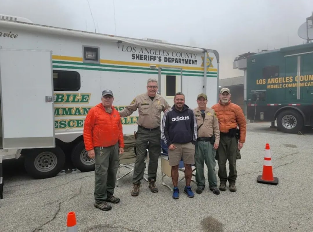
If you’re a long-time reader, you might know that I sometimes get to work with our county’s rescue team, which is all volunteers. Even when I’m not actively working with them I’m aware of just about all of their calls, since I’m also the county’s radio communications coordinator, so I listen to our county’s police, fire, and EMS radio channels 24×7. Yes, I have a very understanding wife.
And there’s one detail I hear on many of those calls: Dispatch tells them, “their cell phone is low on battery.” Seriously: that’s probably the case on about half of their calls.
So let’s pull some common sense lessons out of this Uncommon Sense story. First, if you’re out hiking, especially in mountainous terrain, turn off your freaking cell phone. The reason so many have low batteries isn’t because they started their day at 30 percent. It’s because they’re going in and out of cell service, and the hunting and connection process that a phone goes through to find a tower sucks a lot of battery. Battery life you may need to save your life.
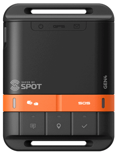
Two, if you hike a lot, consider buying a personal satellite communications device that doesn’t need cellular service.
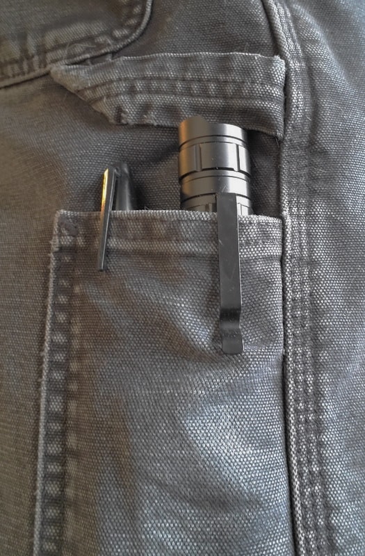
Three, carry some basic supplies. Clothing layers, and a space blanket. Enough food and water to get you through the night. A flashlight — I have one clipped into a side pocket wherever I go, and it not only has a huge battery, but it recharges with a USB-C port. And, four, a USB power pack to charge your phone and your flashlight. I’ll link to the flashlight and power pack I have.
If Compean had seen a helicopter out at night — which is certainly possible, since they might be using night vision to look for his heat signature — he could have gotten their attention from miles away with a few bursts from a flashlight.
Oh, and also consider leaving your location settings “on” for your photos! Just remember your setting so if you, say, upload a photo to Facebook, Facebook knows exactly where you took it, and usually displays at least the general location to anyone who can see the photo.
Next, if you need help and have cell service, don’t text your roommate, who might be in the shower or otherwise not paying attention to their phone, try texting 911, or whatever your emergency number is if you’re not in North America. Not all PSAPs — Public Safety Answering Points, aka the people who answer 911 calls — can handle text messages, but more and more of them can every month. And try calling 911 even if your phone doesn’t show service. If any cell tower picks up a 911 call it will put it through, even if it’s not the carrier you subscribe to. Most people don’t know that. Did you?
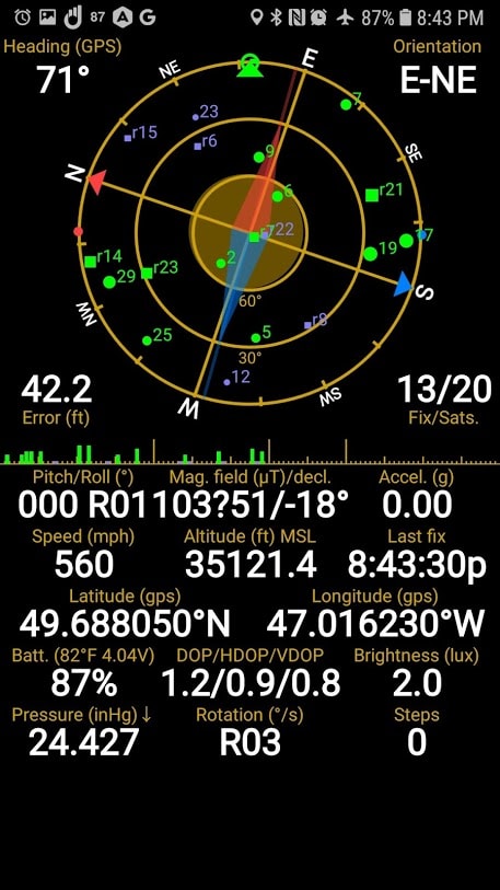
And if you’re going to text a photo, how about a screenshot of your GPS location? Check the Show Page for one of mine that’s perhaps a little surprising. That way it’s clear exactly where you are, including your elevation. I’ll link on the Show Page to the Android app I use. On the iPhone, open your compass app, which includes GPS location info.
When you call 911, even if you do have your location settings turned off, your phone will transmit your location to the PSAP. And unless they tell you to move, don’t: they have your location, and that’s where they’ll send rescuers. It’s better if you’re there when they arrive. And never hang up on a 911 operator until they’re done asking you questions. Then, tell them you’re turning off your phone to conserve battery if you think that’s necessary, and will call back in half an hour to exchange update information.
At least, that’s what people with Uncommon Sense, and even common sense, do. That often means the difference between rescued and …not rescued.
And last, if you do depend on rescue teams in rural areas, remember that they are almost always volunteers. They take time off from work and family to rush out and rescue people. Do the right thing and support them with whatever you can comfortably afford, and I mean cash, even if you don’t think you’ll ever get lost. Because no one ever thinks that they’ll be the ones who need help to not die. It even happens in Los Angeles County.
The Show Page for this episode is thisistrue.com/podcast90. The next episode will be …sometime! There’s still no schedule set.
I’m Randy Cassingham … and I’ll talk at you later.
– – –
Bad link? Broken image? Other problem on this page? Use the Help button lower right, and thanks.
This page is an example of my style of “Thought-Provoking Entertainment”. This is True is an email newsletter that uses “weird news” as a vehicle to explore the human condition in an entertaining way. If that sounds good, click here to open a subscribe form.
To really support This is True, you’re invited to sign up for a subscription to the much-expanded “Premium” edition:
Q: Why would I want to pay more than the minimum rate?
A: To support the publication to help it thrive and stay online: this kind of support means less future need for price increases (and smaller increases when they do happen), which enables more people to upgrade. This option was requested by existing Premium subscribers.
Should you be using your phone while on an airplane?
—
As you can see in the indicators, it’s in “Airplane Mode”. -rc
I’m surprised you didn’t mention another good thing to have with you while hiking, especially if you’re planning to use a less common trail: A paper map of the area (ideally in a ziplock bag or similar to help keep it dry) and, a compass. Granted that won’t help if you get injured and also requires a little preparation — after all you need to know how to use them, but I’ve never yet had either run out of battery. 🙂
The flashlight I have for such occasions has both compass and whistle built in and, like you, I am rarely without it.
—
I can’t put in all the tips: I have to leave readers something to comment about! A whistle is excellent for not losing your voice. -rc
Well done story. Suggest 1 very important item to have not just on a hike but in your vehicle: a camping pocket knife. He could have used it that night and if you are in an accident or see an accident where you need to break the window and even cut the seat belt to get out — guess how many people do not have anything to use to do that. I always carry a pocket knife designed for breaking glass and cutting. Also might suggest a camping flint should you be forced to try to start a fire to stay warm or let rescuers know where you are.
There’s an app (and website) called What3Words that really needs to be popularized as it has the potential to revolutionize rescue operations. How it works is, it has divided the world into 3 meter squares, and each of these squares can be identified by a unique combination of 3 dictionary words. So if you’re hiking and are lost, all you need to do is turn on your location and open the app. The app will provide you with the 3 words that identify your location. The accuracy depends on your location services, but the brilliant bit regarding the app is that once downloaded the app doesn’t need internet access to work. Once you have the 3 words, you just need to text them to 911 or anyone else that can help. The odds of three words going through when you manage to get a signal is a LOT higher than an image going through.
Disclaimer: I have nothing to do with the app. I just think that is a brilliant idea.
—
I have heard of it and think it’s cool, but I’ve never heard our rescue people use it. They get lat/long, in part because that’s what the phones already transmit to the PSAPs without need of a separate app. -rc
Alas, while the idea is cool, they have recently (in the past week) discovered some major challenges with it. The only thing worse than not having a location is having a bad location.
Oh, that IS unfortunate. But hopefully something that can be solved without having to throw out the entire tech or idea.
I came here to mention W3W as well. Like you, I think it’s a great innovation for giving your location in shorthand format over a text message when you don’t have a stable enough connection/battery to send a photo or make a voice call.
Based on their Twitter mentions, it seems to be gaining popularity with emergency services in the UK, and hopefully it’ll spread further over time.
Personally, I use it when I’m trying to give friends a specific spot to meet up, and the address/landmark is too vague. e.g. a side entrance that doesn’t have its own street number.
—
Unfortunately I hadn’t approved the previous comment before you got here. The linked article is from the BBC. -rc